
Our Story: Historic Preservation Guideline - Violated
Beyond the egregious building code and fire code violations, the ADU that the city allowed to be built also violates our City's own Historic Preservation Plan - as the city's own ordinance states that these areas are to be preserved and protected.
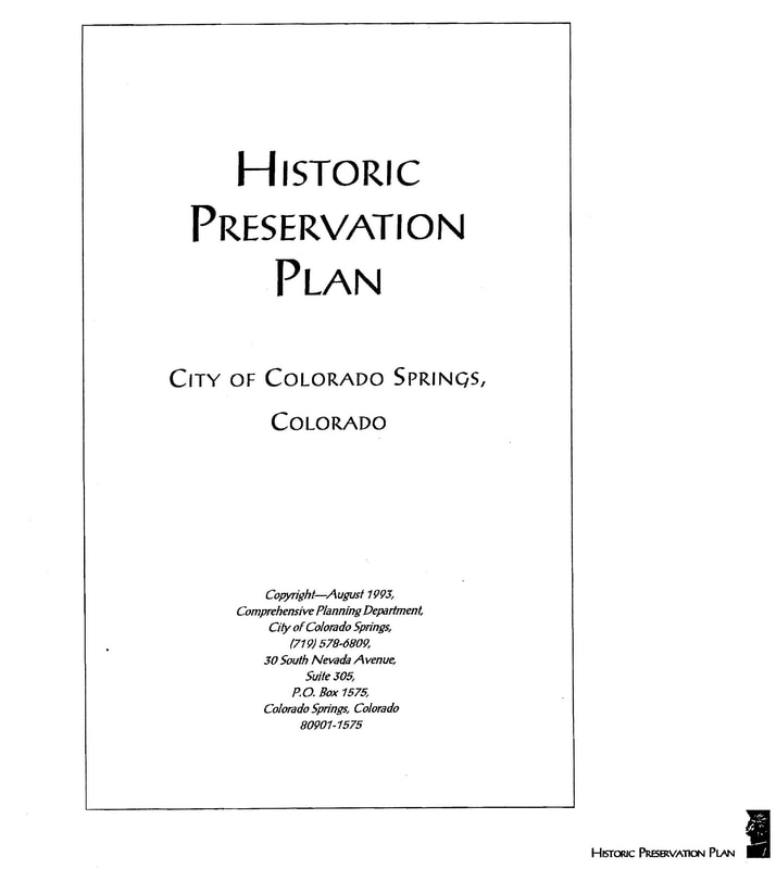
In August of 1993 the City of Colorado Springs published its Historic Preservation Plan.
The link to the plan, in its entirety: https://coloradosprings.gov/sites/default/files/planning/hispresplan.pdf
The Westside, a.k.a., Old Colorado City, is an important historic district. Founded in 1859 it was the first capital of the Territory of Colorado. It was here before Colorado Springs (founded 1871), and before Manitou Springs (1872). Old Colorado City was also designated a National Historic District in 1982.
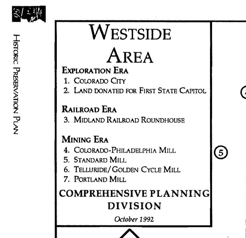
The Historic Preservation Plan lists only five buildings and two areas of special historical significance in the Westside/Old Colorado City area.
The two areas (map below), noted because of their importance in this city's "Exploration Era" are:
1). Colorado City (area 1 on map)
and
2.) Land donated for first state capital (area 2).
Our house is located in this 2nd historic preservation area.
The link to the plan, in its entirety: https://coloradosprings.gov/sites/default/files/planning/hispresplan.pdf
The Westside, a.k.a., Old Colorado City, is an important historic district. Founded in 1859 it was the first capital of the Territory of Colorado. It was here before Colorado Springs (founded 1871), and before Manitou Springs (1872). Old Colorado City was also designated a National Historic District in 1982.
The Historic Preservation Plan lists only five buildings and two areas of special historical significance in the Westside/Old Colorado City area.
The two areas (map below), noted because of their importance in this city's "Exploration Era" are:
1). Colorado City (area 1 on map)
and
2.) Land donated for first state capital (area 2).
Our house is located in this 2nd historic preservation area.
The Westside Areas of Historical Significance are marked on this map, below.
Our street is in AREA 2.
This area is of special significance as it is "Land Donated for First State Capital."
Because of its historic importance, the City's own Historic Preservation Plan states explicitly that this are is to be protected.
Our street is in AREA 2.
This area is of special significance as it is "Land Donated for First State Capital."
Because of its historic importance, the City's own Historic Preservation Plan states explicitly that this are is to be protected.
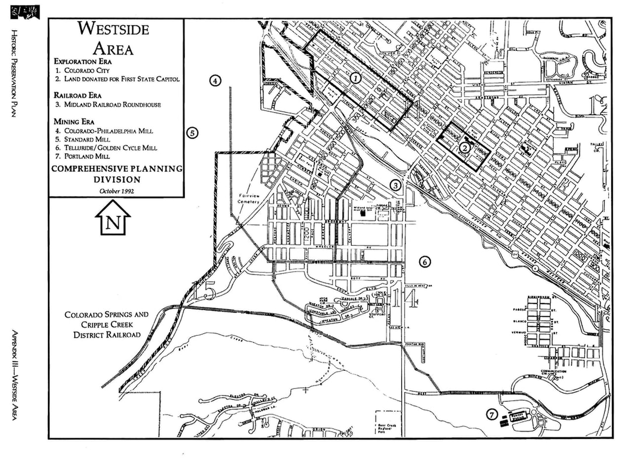
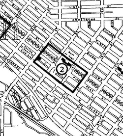
This is a close-up of Area 2: "Land Donated for First State Capital."
As anyone can clearly see, the 1800 west block of Pikes Peak Ave. is clearly in this area.
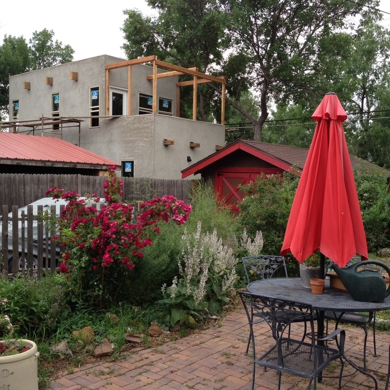
So, not only is the building blatantly and illegally over-sized and in violation of fire code, the city has also allowed this to occur in in a Historic Preservation area.
As anyone can clearly see, the 1800 west block of Pikes Peak Ave. is clearly in this area.
So, not only is the building blatantly and illegally over-sized and in violation of fire code, the city has also allowed this to occur in in a Historic Preservation area.
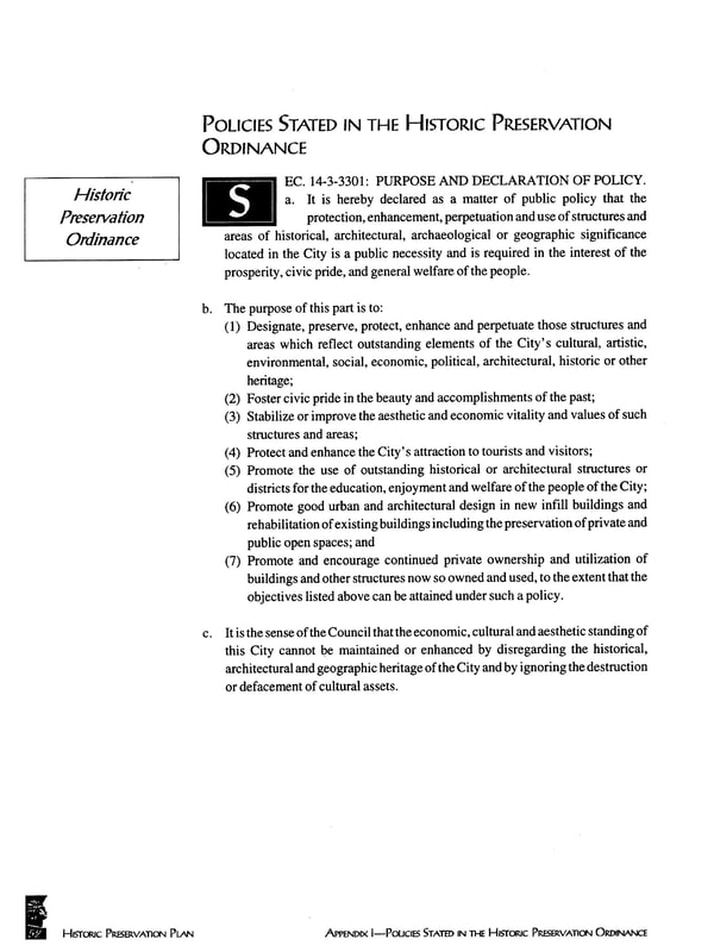
Historic Preservation Ordinance Sec. 14-3-3301:
PURPOSE AND DECLARATION OF POLICY.
a. It is hereby declared as a matter of public policy that the protection, enhancement, perpetuation and use of structures and areas of historical, architectural . . . significance . . . is a public necessity and is required in the interest of the prosperity, civic pride, and general welfare of the people.
Listed as the number one purpose of the Historic Preservation Ordinance:
(1) Designate, preserve, protect, enhance and perpetuate those structures and areas which reflect outstanding elements of the City's cultural, artistic, environmental, social, economic, political, architectural, historic or other heritage.
CONO, which is listed as being involved in the development of this Historic Preservation Plan, was of no help whatsoever to us when we repeatedly reached out for assistance in regard to this illegal building.
Andy and our daughter Lily went before The Historic Preservation Board (all board members appointed by City Council) in September 10, 2018.
Andy told the board of the fire code and size violations and the disregard of ANSI standards.
Not one member, including John Hazelhurst, who has lived on the Westside for years, expressed concern or offered help.
Neither our complaint nor our family members' presence was documented in the meeting's minutes.
ADDITIONAL NOTES:
Beginning at: https://coloradosprings.gov/page/historic-preservation-1
OVERLAY ZONING
In order to protect and preserve the town’s unique and varied history, the City of Colorado Springs employs overlay zoning. Properties zoned with the Historic Preservation (HP) Overlay are required to undergo additional review prior to any construction or modification.
Property owners apply for a Historic Preservation General Application and specify the changes they wish to make. This Application is reviewed and decided by the Colorado Springs Historic Preservation Board. After the Board has approved the proposed work, the property owner is then free to obtain a building permit. For more information on how to apply for a General Application, consult the Overlay Zoning Page.
On the Overlay Zoning Page:
https://coloradosprings.gov/planning-and-development/page/overlay-districts?mlid=29831
I found the following:
OVERLAY DISTRICTS
Properties in Colorado Springs all have a base zone which regulates the types of uses and development within the zone districts. Some properties also have a zoning overlay, which means they are subject not only to the standards of their base zone, but also to the standards of the overlay zone. The City of Colorado Springs currently employs six overlay zone districts; a brief description of each follows. More detail can be found in Chapter 7, Article 3, Section 5 of the City Code.
-and-
HISTORIC PRESERVATION OVERLAY
Certain areas within the City have been identified as historic resources and have been zoned with the Historic Preservation Overlay zone. The purpose of the Overlay is to designate, preserve and protect areas which reflect the City’s historic heritage. Any building within the Historic Preservation Overlay zone is subject to additional review by the Colorado Springs Historic Preservation Board.
I tried, but could not get access to further information:
On the City's "Historic Preservation Board Review" page: https://coloradosprings.gov/planning-and-development/page/historic-preservation-board-review?mlid=35631
I clicked on "Historic Preservation Overlay Zone."
link: https://coloradosprings.gov/planning-and-development/page/historic-preservation
It seems obvious from our city's own Historic Preservation Plan that the area where this illegal ADU stands is part of the Historic Overlay area. However, the exact documentation could not be accessed. After I clicked on the above link for "Historic Preservation Overlay Zone" I received the following screen message:
ACCESS DENIED: You are not authorized to access this page.
* * *
In spite of the roadblock above, I was able to access the City Code: Here it is in its entirety.
Again, violations:
7.3.505: HP - HISTORIC PRESERVATION OVERLAY:
A. Purpose And Declaration Of Policy: It is hereby declared as a matter of public policy that the protection, enhancement, perpetuation and use of structures and areas of a historical or architectural significance located within the City is a public necessity and is required in the interest of the prosperity, civic pride, and general welfare of the people.
The purpose of this section is to:
1. Designate, preserve, protect, enhance and perpetuate those structures and areas which reflect outstanding elements of the City's cultural, artistic, environmental, social, economic, political, architectural, historic or other heritage.
2. Foster civic pride in the beauty and accomplishments of the past.
3. Stabilize or improve the aesthetic and economic vitality and values of such structures and areas.
4. Protect and enhance the City's attraction to tourists and visitors.
5. Promote the use of outstanding historical or architectural structures or districts for the education, enjoyment and welfare of the people of the City.
6. Promote good urban and architectural design in new infill buildings and rehabilitation of existing buildings including the preservation of related private and public open spaces.
7. Promote and encourage continued private ownership and utilization of buildings and other structures now so owned and used, to the extent that the objectives listed above can be attained under such a policy.
8. It is the sense of the Council that the economic, cultural and aesthetic standing of this City cannot be maintained or enhanced by disregarding the historical and architectural heritage of the City and by ignoring the destruction or defacement of cultural assets.
B. Standards For Designation Of Areas For Zoning Overlay: A structure may be designated by Council for historic preservation overlay zoning if it is at least fifty (50) years old, or if not fifty (50) years old, exhibits exceptional importance, and meets one or more of the following criteria as set forth in the following two (2) categories:
1. Historical importance: The structure or area:
a. Has significant character, interest or value, as part of the development, heritage or cultural characteristics of the City, State or Nation;
b. Is the site of a historic event with significant effect upon society;
c. Is identified with a person or group of persons who had significant influence on society; or
d. Exemplifies the cultural, political, economic, social or historic heritage of the community.
2. Architectural importance: The structure or area:
a. Portrays the environment of a group of people in an era of history characterized by a historically important and distinctive architectural style;
b. Embodies architecturally distinguishing characteristics;
c. Is the work of an architect or builder whose individual work has influenced the development of the City;
d. Contains elements of architectural design, detail, materials or craftsmanship which represent a significant innovation; or
e. Contains buildings which, although individually lacking distinction, collectively display distinguishing characteristics.
C. Surveys And Inventories: Surveys and inventories of historic properties have been prepared by the City for downtown, Shooks Run, Old Colorado City, Mesa Springs, Knob Hill, and the west side neighborhood, and such are on file at the Community Development Department. These surveys and inventories as such are now completed or such surveys and inventories as may be completed in the future shall be a part of the City's Comprehensive Plan. Surveys which locate and describe historic structures and areas, and inventories which compile information about historic structures and areas shall be undertaken and updated as funds are budgeted and made available. Owners of surveyed properties shall be notified of the survey results by being given a copy of the survey of their property. A description of the historic preservation ordinance program, the reasons for and the obligations and restrictions and effects of the historic preservation overlay zone shall accompany the survey form.
The City survey and inventory system shall be compatible with Federal and State criteria and consistent with Statewide comprehensive historic preservation planning.
Both the Regional Building Department and the Colorado Springs Fire Department highly value existing historic structures. Each agency is prepared to survey each building's unique life safety qualities and recommend the enhancements most suited for its individual hazards. Contact either agency to obtain a written comprehensive report.
D. Relief To Preserve Historic Resources: The purpose of this subsection is to provide flexibility in the application of development standards and parking requirements for use when strict application of regulations will result in adverse effects to designated historic resources. The City recognizes that historic resources contribute to the unique character of neighborhoods; that many resources exist as legal, nonconforming structures; and that the value of historic resources cannot be replicated once they are adversely altered, moved or demolished.
1. Application: A written request for relief shall be submitted. The request shall include a site plan and a parking lot plan which shows the location, exterior dimensions, and height of all structures and objects, the layout of parking spaces, aisles and access points, and the location and size of the existing vegetation.
2. Findings Necessary To Recommend Relief: The Historic Preservation Board must make all of the following findings in order to recommend relief:
a. The strict application of development standards listed in the base zone and/or parking requirements listed in article 4, part 2 of this chapter, will cause the removal, demolition or adverse alteration of an existing historic resource.
b. The Historic Preservation Board has determined that:
(1) The historic resource meets the criteria for designation of HP - historic preservation overlay as identified in subsection B of this section; and
(2) The historic resource is worth saving; and
(3) The relief is necessary to preserve the historic resource.
c. If the request for relief involves parking requirements, the Traffic Engineer has determined that the surrounding properties will not be adversely impacted by the reduction of the number of required off street parking spaces.
d. The intent of this Zoning Code is preserved.
3. Relief That May Be Recommended: In order to provide greater flexibility in satisfying development standards and/or parking requirements to save historic resources, the following relief may be recommended:
a. Reduction Of Required Front, Rear, Or Side Yard Setbacks:
(1) The base zone regulations regarding front, rear, or side yard setbacks may be waived upon demonstration that a neighborhood standard exists which is less restrictive than the requirements of the base zone.
(2) A recommended waiver of base zone setback requirements shall be no less restrictive than the identified neighborhood standard.
b. Waiver/Reduction Of Parking Design Guidelines; Provision Of On Site, Off Street Parking Requirements As Listed In Article 4, Part 2 Of This Chapter:
(1) The prohibition against backing across a property line may be waived for those parking spaces accessed from an alley if the unparking vehicle is clearly visible from both alley directions.
(2) The prohibition against off site parking spaces may be waived for those parking spaces located within three hundred feet (300') of the property containing the subject historic resource, provided that the off site parking spaces are not located across an arterial street, expressway, or freeway. A guaranteed access agreement will be required as evidence of secured off site parking, and it shall be filed with the County Clerk and Recorder if such a waiver is issued.
(3) One hundred percent (100%) of all required off street parking spaces may be compact spaces. Compact space dimensions are found in article 4, part 2 of this chapter.
(4) The prohibition against tandem parking spaces fulfilling on site, off street parking requirements may be waived.
(5) If the relief allowed under this section is still insufficient to preserve the subject historic resource, a reduction of up to fifty percent (50%) of the minimum number of off street parking spaces required by this Zoning Code may be recommended if determined necessary by the Board to preserve a historic resource.
c. Waiver Of Height Of Building Limitation:
(1) The base zone regulations regarding height of building limitations may be waived upon demonstration that a neighborhood standard exists which is less restrictive than the height of building limitations of the base zone.
(2) A recommended waiver of base zone height of building limitation may be no less restrictive than the neighborhood standard.
4. Issuance Of Relief: Relief to preserve historic resources may be approved when accompanying an overlay zone change request.
E. Applicability: No structure may be erected, reconstructed, structurally altered or demolished on land which is designated historic preservation overlay unless the structure is in compliance with the provisions of this Zoning Code. (Ord. 88-228; Ord. 90-9; Ord. 91-30; Ord. 94-107; Ord. 01-42; Ord. 03-16; Ord. 09-80)
As long time residents of this neighborhood (over three decades), as business-owners and tax payers, we deserve to know what is going on here. Why are code violations being ignored, why are historic preservation guidelines being ignored? These issues impact not only our quality of life and our property values, but also those of our neighbors and the historic integrity of this neighborhood and this city.